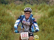
Hoje houve BTT do bom. A etapa cruzou as Black Mountains de Oeste a Este. E que bela etapa.
Tivemos longas subidas, com inclinação q.b. Do género que gosto. Singletrack fluido e rochoso. Descidas rápidas, lentas, inclinadas e suaves.
A secção que mais me agradou foi após a ZA, vários km de subida mantida por um vale glaciar, sempre com o trilho a marcar a encosta. Depois desta subida tive a queda do dia, no "rock garden" que o Dave nos tinha avisado. Ate o GPS saltou. Voltei a montá-lo, mas no fim da descida olhei para ele e tinha fugido de novo. Felizmente um membro da organização que estava na descida já o tinha apanhado e evitou-me andar para cima e para baixo a procura dele...
No total 58km (segundo o meu GPS voador) em 3h50.
Amanhã há mais, segundo o programa mesma distância, mas mais fácil.
Today we had some good MTBing. The stage traversed the Black Mountains from west to east. It was a great stage.
There were long climbs, neither too steep nor to easy (just as I like them). Flowy and rocky singletrack. Fast, slow, step and and tranquil downhills. My favorite section was right after the feed station, several miles of climbing on a glacial valley, you could always see the trail on the slope of the hill, and great view to the other side and bottom of the valley.
After that the days crash, at the rock garden we had been warned about. Even the GPS popped out. I did put it back on, but when i looked at it at the end of the climb, it wasn't there... I was making my way up when a member of the staff showed it to me from higher up. He had already picked it up. Good for me, that avoided a load of walking.
A total of 58km (according to my GPS) in 3h50.
More riding tomorrow, same distance but easier.


Sem comentários:
Enviar um comentário